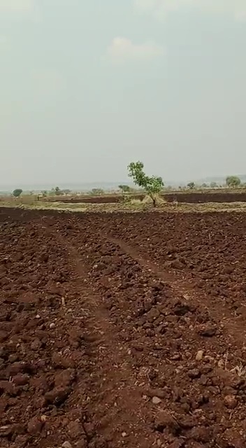
Agricultural land for Sale in Marpally (M) Mallikarjunagiri (V)


Agricultural land for Sale 

Land Size = 10 Acers 10 Guntas 

Land Rate = 65 Lacks per 1 Acer 

Village- Mallikarjunagiri 

Mandal- Marpally 

Dist - Rangareddy 

Hyderabad 

Telangana 

2 Bowells  Available 

2 Goat Farming Sheds 

NH65 Mumbai Highway (Sadasivpet)to Land 26 K.M

Mekavanampally to Land 6 K.M

Vikarabad to Land 35 K.M

Sangareddy to Land 31 K.M 

Financial District to Land 70 K.M .

Mallikarjunagiri is hamlet in Marpally Mandal in Rangareddi District of Telangana State, India. It comes under Bilkal Panchayath. It belongs to Telangana region. It is located 52 KM towards North from District head quarters Hyderabad.10 KM from Marpally(Kalan).

Mallikarjunagiri is surrounded by:

East towards Sadasivpet Mandal, 

North towards Munpalle Mandal,

South towards Mominpet Mandal,

West towards Kohir Mandal.

Sadasivpet, Zaheerabad, Sangareddy, Vikarabad  are the near by Cities to Mallikarjunagiri.

This Place is in the border of the Rangareddi District and Medak District. Medak District Kohir is west towards this place .

Land for Sale in Munipally


 ♻️Agricultural land for Sale♻️ 

🍀3 Acres 33 Guntas

🍀Price : 1Cr 50Lacks per 1 Acar

🍀100 Feets road 1st Bit

🍀Munipally (village)

🍀Munipally (Mandal)

🍀Sangareddy (Dist)

🍀Telangana 

🍀NH65 Mumbai Highway (Budhera X Road) to 4 K.M Distance 

🍀Sadasivpet Town to 17 K.M Distance 

🍀Sangareddy Town to 35 K.M Distance 

🍀Muthangi Outer Ring Road to 49 K.M Distance 

🍀Hyderabad Finance District to 72 K.M Distance 

🍀Mail Us- Apexspacegroup@gmail.com 

🍀Contact Us-8919634307.


House for Sale in Sangareddy


House for Sale Sangareddy (Under Construction)

West Facing

130 Square yards 

Price : 1Cr 40 Lacks 

NH65 Mumbai Highway to 500 Meeters Distance  

6 KM Distance from IIT Hyderabad (Kandi)

15 KM Distance from Sadashivpet 

18 KM Distance from Muthangi (Outer ring road)

21 KM Distance from Patancheru 

26 KM Distance from BHEL Hyderabad 

33 KM Distance from Kamkole Toll Plaza 

33 KM Distance from Miyapur Circle 

35 KM Distance from Kondapur Junction Hyderabad 

40 KM Distance from Financial District 

43 KM Distance from Narsingi Junction 

50 KM Distance from Zaheerabad Town 

70 KM Distance from Hyderabad 

Near Sunrise Hospital 

Bypass road 

Sangareddy 

Hyderabad 

Telangana.


Land for Sale in Uddandapur (V) Tandur (M)


Land for Sale in Uddandapur (V) Tandur (M)

✅Land Size = 4 Acers 

✅Land  Rate = 25 Lacks per 1 Acer

✅Black Soil

✅B.T Road 2nd  Bit (15 Meeters Matti Road Axis) 

  Address: 

✅Village = Uddandapur

✅City = Tandur (Mandal)

✅Dist= Rangareddy

✅Hyderabad 

✅Telangana

Uddandapur is a Village in Tandur Mandal in Rangareddy District of Telangana State, India. It belongs to Telangana region. It is located 67 KM towards west from District head quarters Hyderabad.

 Uddandapur is surrounded by:

 East towards Yalal Mandal,

 West towards Basheerabad Mandal,

 South towards Kodangal Mandal.

This Place is in the border of the Rangareddy District and Mahbubnagar District. Mahbubnagar District Kodangal is South towards this place .


Land for Sale in Thangadapally (V) Sadashivpet (M)


Land for Sale in Thangadapally (V) Sadashivpet (M)

✅Land Size =12 Acers 

✅Land  Rate = 60 Lacks per 1 Acer

✅Black Soil

✅Matti Road Bit

Address: 

✅Village = Thangadapally

✅City = Sadashivpet (Mandal)

✅Dist= Sangareddy

✅Hyderabad 

✅Telangana

Thangadpalle is a Village in Sadasivpet Mandal in Sangareddy District of Telangana State, India. It belongs to Telangana region. It is located 24 KM towards west from District head quarters, Sangareddy 8 KM from Sadasivapet municipality.

Maddikunta (3 KM) Suraram (4 KM) Aroor (4 KM),Ch.konapur (6 KM),Ankanpalle (7 KM) are the nearby Villages to Thangadpalle. 

Thangadpalle is surrounded by:

South towards Mominpet Mandal, 

West towards Marpally Mandal,

East towards Kondapur Mandal, 

North towards Munpally Mandal.

This Place is in the border of the Medak District and Rangareddy District. Rangareddy District Mominpet is South towards this place .


Alekya Infraa Devlopers One Acre and Half Acre Project


ALEKHYA INFRAA DEVLOPERS 

Opportunity to double your investment in Short time period,

buy one acre or half acre, after spot registration you have to be development general power of attorney for this land company,

Apply to DTCP in 9 months and develop 1800 yards per acre 900 yards for half acre, yard for buying you in acres Only 9750/-,

Company will start selling plots by fixing the rate of 18000/- per yard with DTCP with  LP in 12 month, means your investment will be doubled after 12 months. 

*(Mumbai Highway Road Facing, Near Aroor (MRF) Sadashivpet 10 acres of DTCP approved late is being sold at 18000/- Square yards.

One Acre or half Acre will be registered and given to the buyers, after DGPA to the company, it will be developed as plots with DTCP approval)* 

Complete Details: 

One Acre:

1 ACRE (Price): 1,75,00,000/- 

Customer Share 1800 Square yards

Booking Amount 5,00,000/- 

Spot Registration/30Days

Registration Charges by Customer Only

Total Completion Period 12 Months 

DTCP Approval in 9th Month 

Half Acre:

1/2 ACRE (Price): 87,50,000/-

Customer Share 900 Square yards

Booking Amount 2,50,000/- 

Spot Registration/30Days

Registration Charges by Customer Only

Total Completion Period 12 Months 

DTCP Approval in 9th Month 

1. Customer Should give GDPA immediately after Sale Deed.

2. Company will apply for DTCP Approval 9th Month.

3. Company Launching price after DTCP Approval is 18000/- per Square yard.

4. Conversation, DGPA documents Charges, DTCP Approval Charges and Devlopment Charges will borne by the Company only.

5. After DTCP Approval plots will be allotted as East 50% & West 50% Only.

6. After DtCP Approval Supplementary Deed Will be made between Customer & Company. 

7. Fixed Price.

For complete details: 8919634307


Land for Sale in Beerol (V) Bantaram (M)


Land for Sale in Beerol (V) Bantaram (M)

✅Land Size = 10 Acars 

✅Land  Rate = 36 Lacks per 1 Acar

✅Red Soil 

✅Matti Road Bit

Address: 

✅Village = Beerol  

✅City = Bentwaram (Mandal)

✅Dist= Vikarabad 

✅Hyderabad 

✅Telangana

✅Vikarabad to 15 KM Distance 

✅Mominpet to 23 KM Distance 

✅ Shankarpally to 40 KM Distance 

✅Bhel ( Hyderabad )to Land 66 K.M Distance 

Beerol is a Village in Bantwaram Mandal in Vikarabad District of Telangana State, India. It belongs to Telangana region . As part Telangana Districts re-organisation, Beerol Village Bantwaram Mandal re organised from Rangareddi District to Vikarabad district. It is located 38 KM towards west from District head quarters Hyderabad. 8 KM from Bantwaram.

Kareempur (4 KM),Peelaram (4KM), Jinnaram (4 KM),Rallachittempally (5 KM),Madanpalle (5 KM) are the nearby Villages to Beerol.

Beerol is surrounded by 

East towards Vikarabad Mandal and Nawabpet towards, 

North towards Mominpet Mandal,

South towards Dharur Mandal.


Land for Sale in Raipalle (V) Raikode (M)


Land for Sale in Raipalle (V) Raikode (M)

✅Land Size = 2 Acers 

✅Land  Rate = 68 Lacks per 1 Acer

✅Black Soil

✅Matti Road Bit

Address: 

✅Village = Raipalle

✅City = Raikode (Mandal)

✅Dist= Sangareddy

✅Hyderabad 

✅Telangana

Raipalle (pattikarchal) is a Village in Raikode Mandal in Medak District of Telangana State,India. It belongs to Telangana region. As part Telangana Districts re-organisation,Raipalle (pattikarchal) Village Raikode Mandal re organised from Medak District to Sangareddy district. It is located 48 KM towards west from District head quarters Sangareddiy.

Raipalle (pattikarchal) is surrounded by :

North towards Regode Mandal, 

South towards Jharasangam Mandal,

North towards Manoor Mandal,

West towards Nyalkal Mandal.

Zahirabad,Bidar,Sadasivpet,Sangareddy are the near by Cities to Raipalle (pattikarchal).


Plot for Sale in Sangareddy


Plot for Sale in Sangareddy 

West Facing

188 Square yards 

Price : 23000 per Square yard  

HMDA Layout 

NH65 Mumbai Highway to 200 Meeters Distance  

6 KM Distance from IIT Hyderabad (Kandi)

15 KM Distance from Sadashivpet 

18 KM Distance from Muthangi (Outer ring road)

21 KM Distance from Patancheru 

26 KM Distance from BHEL Hyderabad 

33 KM Distance from Kamkole Toll Plaza 

33 KM Distance from Miyapur Circle 

35 KM Distance from Kondapur Junction Hyderabad 

40 KM Distance from Financial District 

43 KM Distance from Narsingi Junction 

50 KM Distance from Zaheerabad Town 

70 KM Distance from Hyderabad 

Shilpa Venture 

Sangareddy 

Hyderabad 

Telangana.


Land for Sale in NagireddyPally (V) Nawabpet (M)


Land for Sale in NagireddyPally (V) Nawabpet (M)

✅Land Size = 5 Acars 10 Guntas

✅Land  Rate = 2Cr per 1 Acar

✅Red Soil 

✅Matti Road Bit

Address: 

✅Village = Nagireddypally  

✅City = Nawabpet (Mandal)

✅Dist= Vikarabad 

✅Hyderabad 

✅Telangana

✅1 K.M Distance from Nawabpet to Vikarabad road 

✅Vikarabad to 11 KM Distance 

✅Mominpet to 20 KM Distance 

✅ Shankarpally to 24 KM Distance 

✅Bhel ( Hyderabad )to Land 48 K.M Distance 

Nagireddypally Village in Nawabpet Mandal Vikarabad District of Telangana State, India. It comes under Keshavapally Panchayath. It belongs to Telangana region. it is located 57 KM towards west from District head quarters Hyderabad. 30 KM from Nawabpet 

Ghanpur (5 KM) Patloor (5 KM) Buchanpally (6 KM)Panchalingal (6 KM)Kotmarpally (9 KM) are the nearby Villages to Nagireddypally. 

Nagireddypally is surrounded by

West towerds Kohir Mandal,

South towards Bantwaram Mandal,

East towerds Mominpet Mandal,

North towerds Munpalle Mandal,

Zaheerabad,Sadasivpet,Vikarabad,Sangareddy are the near by Cities to Nagireddypally.

This Place is in the border of Vikarabad District and Medak District. Medak District Kondapur is East towards this place .